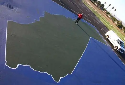
By combining the digital detail of Computer-Aided Design and Drafting (CADD) and the high speed and accuracy of robotic total station surveying, U&R has created the “World’s Largest Dimensionally Accurate Map of California.”
As part of the Fremont Unified School District’s Health and Safety Bond, U&R was contracted to prepare plans for playground reconstruction at Azevada Elementary School. U&R president, Frank Rosenblum, took his love of maps to the field by designing a map of California for the playground surface. DRYCO Construction, Inc. of Fremont, donated materials and labor to place tennis court surface paints along the lines laid out by surveyors from U&R. The map—at a scale of one inch to one mile—is about the size of a standard elementary school basketball court.
Now teachers and students have a new, interactive way to study state geography. And, with latitude and longitude lines included on the map, students can easily locate and add details such as cities, roads, and geographic features. This map is so large that it just might show up in the next satellite photos from Google Earth!